Explore Britain's Top Adventure Locations

Britain is beautiful, perfectly proportioned and small enough that you can explore it properly without having to blag an enormous career break. And with so much variety - superb coastline, idyllic islands, luscious landscapes and incredible views - crammed into such a small area, Britain really is the perfect adventure playground. On this page you’ll find oodles of inspiration for your next adventure, from location highlights to our adventure planning template (road trip coming soon!) It’s the perfect online complement to our Joyously Busy Great British Adventure Map. Read on to explore further…
ROOOOOOAD TRIP!
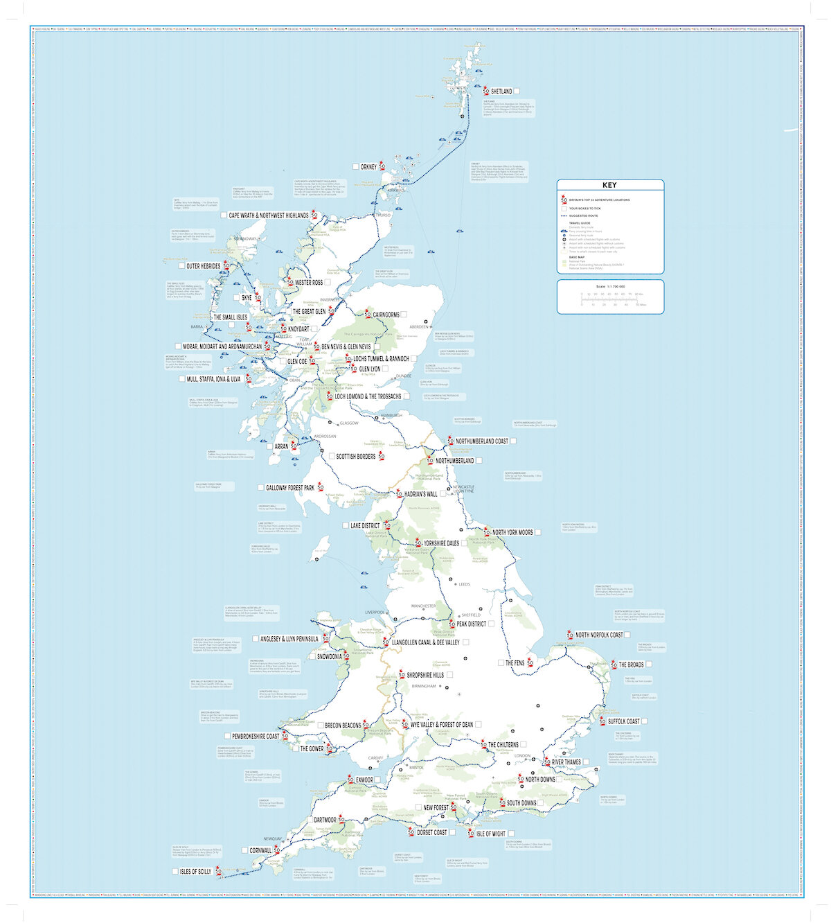
Hit the road for a proper Great British adventure, admiring the finest scenery in the land as you go. Here you can download a map of Britain’s top 50 adventure locations, all of them connected by a rather ambitious road trip…
Plan a great adventure
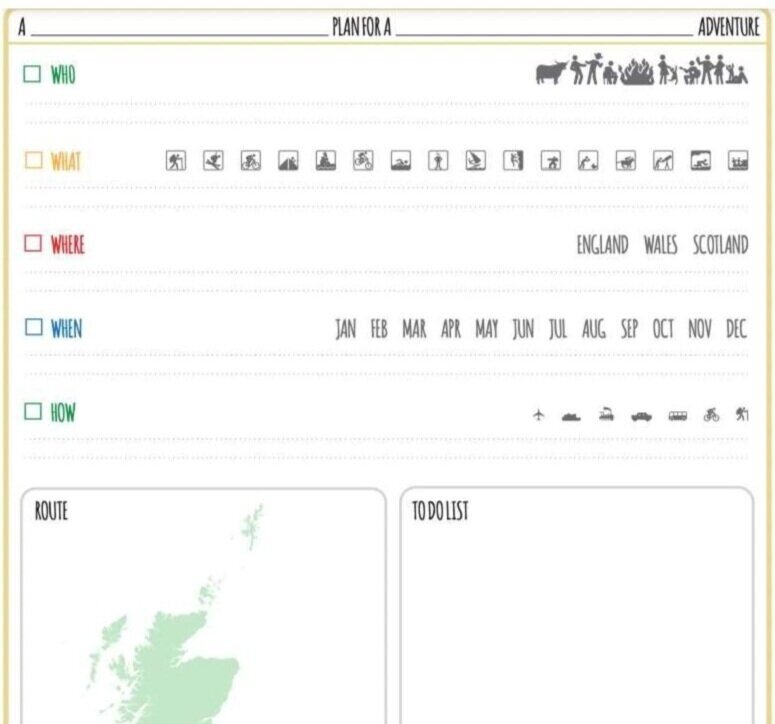
Looking for something to help turn all the inspiration and knowledge from your Joyously Busy Great British Adventure Map into an epic adventure? We’ve got just what you need - ST&G’s Adventure Planning Template.
The most remote places in Britain (and why you should pay them a visit)
Crowds cramping your holiday style? Even on a small-ish island chain like Britain, it’s still possible to experience true remoteness. Here’s how…
Britain’s top 12 adventure locations
Brecon Beacons
Stretching 45 miles from Llandeilo in the west to the English border, the mighty Brecon Beacons is made up of four distinct areas. From west to east: Black Mountain (high moors, glacial lakes), Fforest Fawr (spectacular waterfalls), Brecon Beacons (distinctive, flat-topped hills, including Pen Y Fan, the highest point at 886m), and the Black Mountains (gentler heathland ridges). So, just to recap: the Brecon Beacons are part of the Brecon Beacons, but the Black Mountain is nothing to do with the Black Mountains. (Except there is in fact a Black Mountain within the Black Mountains). Well, that's got our popty-ping going ding, we can tell you.
Cape Wrath & the North West Highlands
Remote, wild and accessible only via boat across the Kyle of Durness and a long off-road bike / hike, Cape Wrath is a destination you have to work at to reach. It's worth it when you do (and the cafe will open whenever you arrive). John O'Groats it ain't. The name has nothing to do with anger - it's old Norse for "turning point". To the east and south are two NSAAONBs: North-West Sutherland (prime peak-bagging territory) and the Kyle of Tongue (top for wildlife spotting). The coastline has a winning combination of crazily-contoured cliffs and beautiful beaches (like Sandwood Bay, Kearvaig and Pocan Smoo). Further south, the Assynt-Coigach NSA possesses some of Britain's very best landscapes, including possibly our most iconic mountain, Suilven. Also the stunning Summer Isles, a paddling paradise.
Lake District
Revelling in its World Heritage status, this perfectly-proportioned arrangement of high hills and deep glacial lakes is one of Britain’s best-loved adventure destinations. Too many highlights to squeeze into this short article... but how about Bassenthwaite, Ullswater, Wastwater, Rydal Water and Derwentwater for lakes? Helvellyn, Haystacks, Blencathra and Great Gable for fells? Views from Gummer's How, Friar's Crag or Wasdale Head? If it's all too much, maybe pause to marvel at a lonely cloud and decide whether you’re more Wordsworth, Beatrix Potter or Withnail. Highest point (and England's too): Scafell Pike (978m).
Anglesey
Anglesey is Wales’ largest island - and it’s pretty big in the adventure stakes too. With glorious beaches sprinkled along a coastline that's almost entirely AONB, this alluring outpost is a hub for pretty much all the watersports you’ve ever heard of (and some of the ones you haven’t - spot of ‘sea level traversing’, anyone?). Two great long-distance cycling routes also start / finish here. Highest point: Holyhead Mountain (220m). Across the Menai Strait, heading south, you come to the luscious Llyn peninsula. It’s another classy coastal AONB, with sandy beaches aplenty, fine surf and the wild, enigmatic Bardsey Island teasingly close to the south-west tip.
Shetland
Around 100 islands, of which 16 are populated, halfway to Scandinavia both geographically and culturally. Britain's northernmost point (Out Stack), Foula’s ginormous cliffs, Fair Isle (the remotest inhabited part of Britain), Papa Stour's sea-cave tunnels stretching under the island, the northern lights in winter, 1,700 miles of coastline and many golden sandy beaches: highlights all. Britain's best bus shelter is pretty tidy too. Highest point: Ronas Hill (450m).

St. Ninian's Isle, Shetland (Visit Scotland)
Peak District
Yet another example of Britain trying to confuse people (see also New Forest, Brecon Beacons, et al): the Peak District has no peaks. Somebody call Trading Standards. Split between the Dark Peak's moorland in the north and the White Peak’s limestone dales to the south, Britain's first national park (established in 1951) has been the spiritual home of the national parks movement since the Kinder trespass in 1932. Great hills, wild and spectacular scenery, caves in abundance. Highest point: Kinder Scout (636m). Other highlights: Mam Tor, Stanage Edge, White Brow Hill, Bleaklow and Black Hill.
Outer Hebrides
An utterly alluring island chain joined by causeways and ferries, the Outer Hebrides are home to some of the world's finest beaches. So much so that, in 2009, a photo of one of them (Berneray) was used by a Thai tourist resort for an advertising campaign - whoops! The 150 mile walk / drive / cycle to the Butt of Lewis (yup, you read that right) is one of Britain's great journeys. Other highlights include the Callanish Stones on Lewis, the Golden Road on Harris, and ludicrous beaches like Scarista, Luskentyre, Hosta and those on Vatersay and Barra. The latter is also the site of the world's only scheduled flight whose runway is a beach. Further to the west, St. Kilda beckons.
Pembrokeshire
Britain's only fully coastal National Park has 260 miles of coastline - impressive cliffs, big sandy beaches, small sandy beaches, wooded estuaries, wild inland hills, harbours, coves and several wildlife-rich islands close by... Oh, and a few more sandy beaches. So it won't be a surprise to hear it's a great watersports destination. The entire coast is also walkable thanks to the Pembrokeshire Coast Path, one of three long-distance national trails in Wales, and part of the newfangled Wales Coast Path. Highest point: Foel Cwmcerwyn (536m).
Skye
Possessing some of Britain's most extreme terrain, Skye is an island of delightfully-named peninsulas, jagged peaks (such as the Inaccessible Pinnacle along the Black Cuillin ridgeline), almost alien landscapes like the Quiraing, and all sorts of other eye-popping scenery. Camasunary Bay (good remote beach / hill / hike / bothy combo), the view of the Cuillin from Elgol, Fairy Glen, the cliffs of Kilt Rock... if you've ever badmouthed Britain for a lack of exciting scenery, go wash your mouth out (then get to Skye). Highest point: Sgurr Alasdair (992m).
Cornwall
Kernow: a proud peninsular paradise and masterclass in how to do coastlines. More brag-worthy beaches - big and small - per mile, than almost anywhere, and classic coastal adventuring to match. Surfing on the north coast, SUP on the south, climbing at the tip of the boot… The moorland of Zennor and Bodmin, Kynance Cove and other delights of the Lizard, the glorious gardens, the Fal and Helford estuaries, are all highlights. And you can walk around the whole thing on the South West Coast Path: another classic British journey.
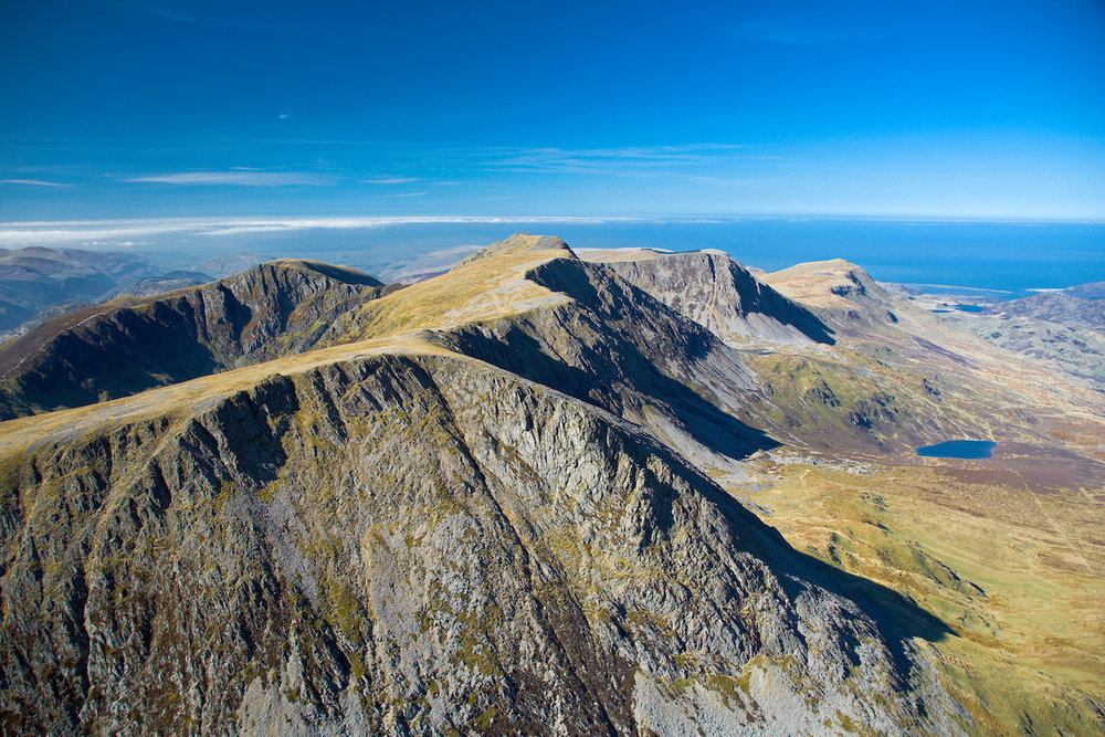
Snowdonia
Snowdonia, all 823 square miles of it, has it all: not only the highest peak in Britain outside the Scottish Highlands, but also a train to get you to the top, making Snowdon / Yr Wyddfa (Great Tomb) at 1085m Britain's most accessible peak. Elsewhere, there are more iconic mountains (Cader Idris, Tryfan, the Rhinogs, Glyder Fach and Glyder Fawr), amazing roads, hiking and mountain biking routes, forests, waterfalls... and even some white water action at Bala. Also 23 miles of coastline, much of it sandy and visible from the peaks. Tidy darts.

Cader Idria, Snowdonia (Crown copyright 2018 / Visit Wales)
Cairngorms
Britain’s largest (and wildest) national park contains 4 of its 5 highest peaks and its biggest native forests. Skiing, snowboarding and ski touring country in winter / spring (when it’s good it’s great) and hiking, biking and wildlife-liking the rest of the time. Highlights include the Rothiemurchas Forest, Loch An Eilein, Royal Deeside, walking to Sgor Gaoithe / Sgoran Dubh Mor or through the Lairig Ghru, and canoeing down the Spey in full flow. Plus, of course, the beach and watersports at Loch Morlich. Highest point: Ben Macdhui at 1309m (watch out for the Big Grey Man).
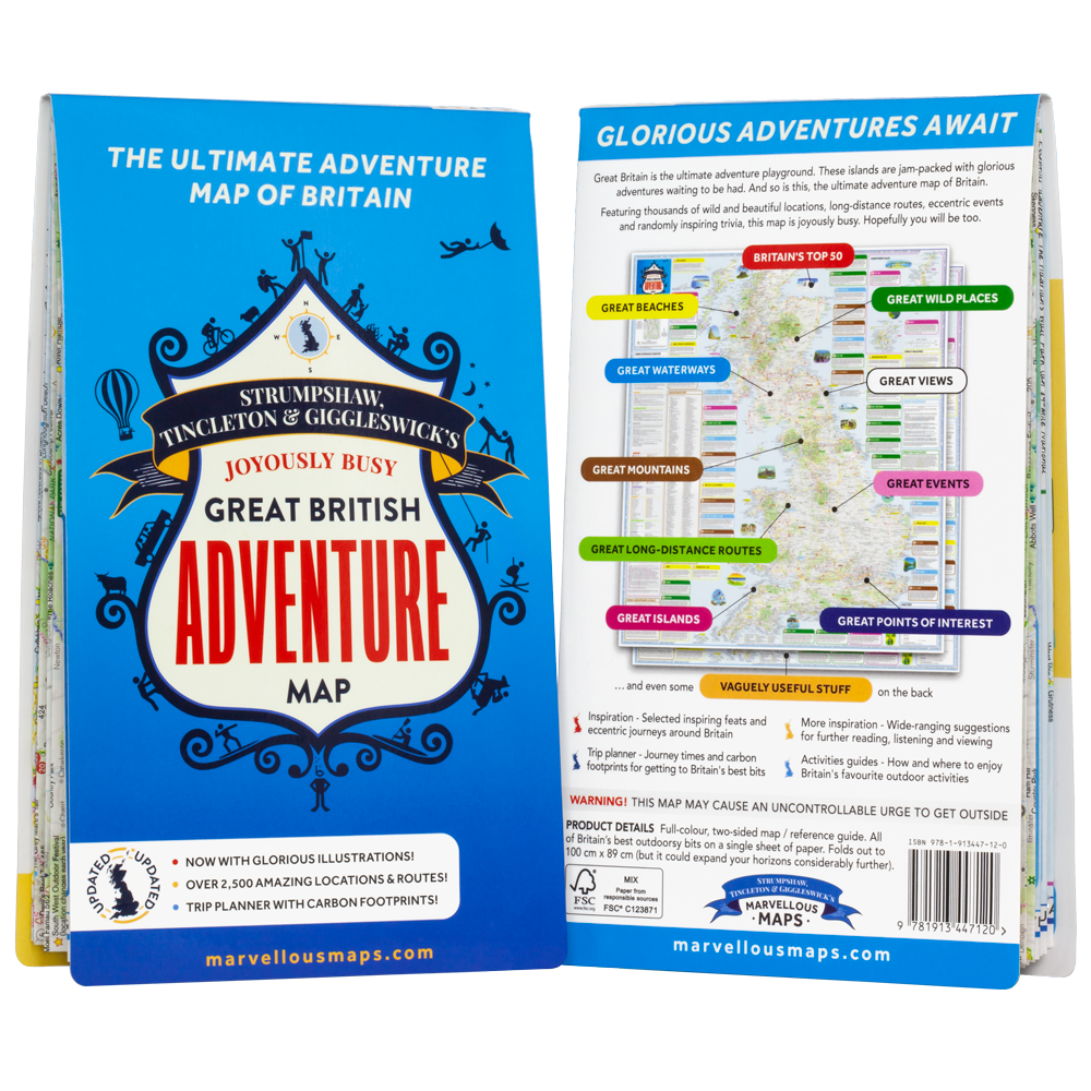
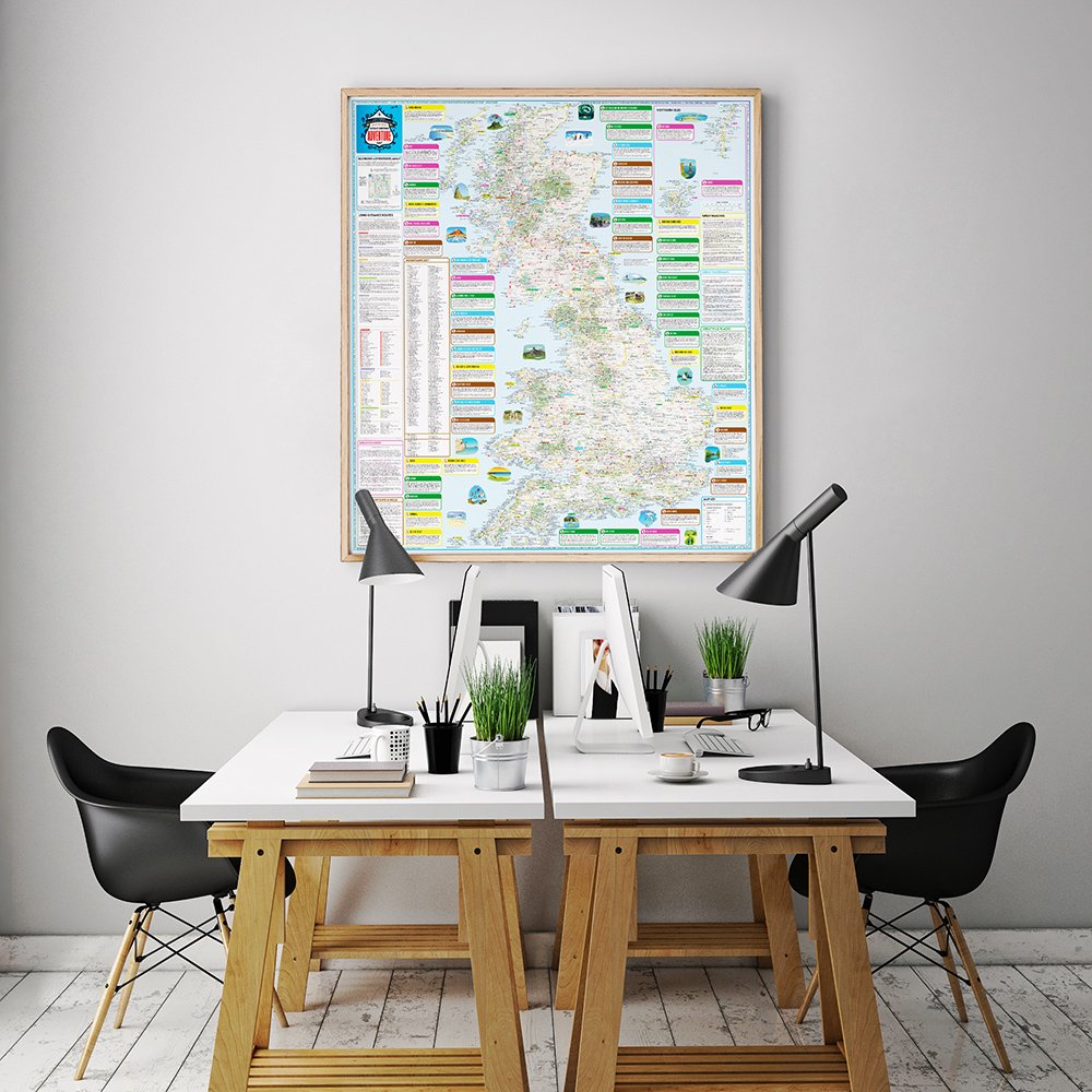
The Map
Britain’s very best adventure locations, including the selection on this page, are the subject of the Joyously Busy Great British Adventure Map. Available in 3 formats (fold-out, flat or framed) from £14.99. If you’ve got the map and have any feedback or suggestions for the next edition, we’d love to hear from you - email us at hello@marvellousmaps.com.

Win A Marvellous Map!
Take this ludicrously quick survey to let us know where in Britain you've been and where's next on your list... and you could win BIG!